Winter Storm Warnings End At 9AM Wednesday.
Additional Wind Chill advisories are possible afterwards
Late evening update:
OK let’s wrap this baby up…I know a lot of you hate snow…maybe not all of you though…and if you love following the weather…try and look outside tomorrow morning…the snow is so powdery…it’s literally glistening…I think they call it Champagne snow…but I’m sure skiers love it.
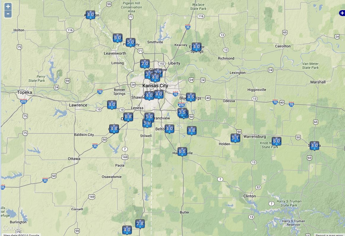
I just measured about 8 1/4″ here and we’ll probably end up with 8.5 or close to 9″…getting lots of reports of 8-12″ totals around the region with a stray 14″ report from the west side of Olathe…they back edge of the snow, combined with the fluffy nature and the bigger snowflakes has done the trick and tacked on additional 1-3″ amounts…or close to it. Wow!
As we dig out tomorrow…again please remember to watch the forecast carefully tomorrow night for THU AM…see the previous update.
Have a great night and for those of you who have wanted snow…Mother Nature has granted your wish.
JL
Mid evening update:
So the last gasp of the storm is moving in…and already we’re seeing more of the 10-12″ snow totals coming into the weather center. The last gasp of the storm though will continue the moderate to at times heavy snow in parts of the area, especially along the I-70 corridor through 11PM or so…additional 1+” totals are possible with this heavy snow as it moves across…it might be weakening just a pinch on the latest radar animation…but boy this is impressive.
Here is a look at the NWS radar from Pleasant Hill showing the last gasp of the storm that won’t quit!

The back edge according to the NWS radar in Topeka is just to the west of Topeka and is weakening as well…
While I have your attention…I want to remind you about the low temperature potential on THURSDAY morning…I continue (as I have for about a week now) to be VERY concerned about how cold the low temperatures can get…and as I’ve mentioned several times before IF skies are clear…temperatures with the snow pack…the clear skies…and the light winds have the potential of tanking to -10 to -25° in most of the area. The record low for the date is -19…and the all-time record low for KC is -23° set back in 1989. PLEASE pay attention to this facet of the week…as many pipes may freeze in the region, including some pipes that typically don’t freeze in the extremely cold conditions.
JL
Early Evening Update:
Please scroll down towards the earlier morning blogs for lots of radar animations etc…this storm is now moving into the expected :storm that won’t quit” phase and it still is packing a pretty good punch with moderate to heavy snow at times in the area highlighted by the tweet I just sent out (fox4wx) on twitter.
This is the storms core if you will and it actually is impressing me more than I thought it would…in terms of the snow it’s producing. I mentioned earlier some areas will see an additional 2-4″ of snow out of this part of the storm…so when things are all said and done…the vast majority of the region will have 5-9 or 10″ on the ground and I’m almost convinced that some parts of the area, perhaps on the NW side may come in over 10″-12″ or so…still waiting on some decent snowfall reports…but that area in the darker green on the following image should be putting down some impressive snow rates…
Radar impressive w/ snow falling at a good clip acr. area…as mentioned earlier 2-4" possible #KC #MOwx #KSwx pic.twitter.com/755giUHGd2
— Fox 4 Weather KC (@fox4wx) February 5, 2014
So let’s update the timeline…
Now through 12AM…snow continues, heavy at times with an additional 2-4″ possible in areas that get hit the hardest…mostly from KC northwards.
After 12AM: the snow will diminish and the heaviest accumulations will wind down…again all told widespread 6-10″ amounts will be common and there will be locally higher amounts in spots…
Also the winds are on the increase tonight…right now we’re getting sustained 21 MPH winds…and we should see the increases continue this evening. Wind chills are near 0° right now and that will progressively get worse overnight tonight
This is one impressive storm that “keeps on giving”…we should see a rapid end to the snow by about 3AM from the west side to the east side.
Misery luvs company rite? Close to 79 million people r under a #winterstormwarning (in pink) now inc. #KC pic.twitter.com/OnCsay23uy
— Fox 4 Weather KC (@fox4wx) February 5, 2014
JL
Late Afternoon Update:
We’ve been tracking the progress of a dry slot that has been pushing towards the area…it made it into the south side of KC and is now sliding off towards the east of the KC Metro. This has caused a reduction of the snowfall for a bit…but latest radar trends continue to point to another prolonged period (at least 3-6 more hours) of at times moderate snow moving back into most of the KC metro area. Amounts thus far are in the 4-almost 7″ range and for areas with the higher totals, let’s say from Lees Summit westwards through Stanley and Olathe…then NW through KS and along the MO River and westwards…amounts may exceed 9″ in spots. Already Olathe is closing in on 7″ and there are 6-7″+ reports from Weston and Leavenworth…in all I’m expecting another 2-4″ for areas mentioned above.
It does appear that the worst of the snow may be over from Paola to Warrensburg to Sedalia and SEwards at this point…although we’ll continue to watch the radar trends closely.
Here are some of the reports from noon through 4PM
More coming this evening…
JL
After Lunch Time Update:
Satellite pictures are showing a dry slot zipping up into the area…this will then rotate away from KC early this evening allowing for a reduction in snow rates, followed by an early evening uptick, although not to the degree that we’ve seen in terms of the heaviest of the snows during the late AM and early PM. You can see the dry slot on the satellite images
Accumulations of 1-4+” are very common through the KC metro…but areas just south of Downtown KC from Freeman to Osawatomie-Harrisonville-Raymore-Holden have seen 4-5″ and I think we’re seeing where the heaviest snow out of this will be setting up… from essentially the near or south of the I-70 corridor southwards towards the 50 highway corridor. Snowfall rates are nearly 1″/hour in spots now and perhaps a bit more.
Amounts farther northwards (36 highway corridor) are not as heavy and this region will see lower storm total accumulations by the time things are all said and done.
All else continues to proceed pretty much according to plan. The bulk of the storm is now in progress and will, as you can see from the animating radar below, continue for about another 6 hours or so. All of our model data indicates that we should end up with about 6/10s-8/10s” liquid equivalent out of this…and when factoring in the ratios with the air getting colder…that equates to roughly 5-9″ of snow through many parts of the viewing area and this will roughly be in a north to south fashion…i.e. KCI may end up closer to 5″ while parts of the southside may be closer to 7-9″…where amounts thus far have been in the 4-6″ range
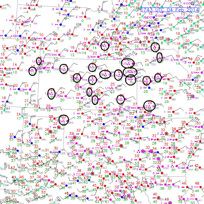
Here is the 11AM surface map and I’ve highlighted all the reports of at least moderate snow…that’s represented by the 3 *’s that you see between the temperatures in RED and the dewpoints in GREEN. Where you see 4 *’s…that is a report of heavy snow. Olathe reported heavy snow at 11AM.
One of our data providers, Weatherbell.com have made their HRRR model available to us and I’m making it available to you…this is the same model that I showed you earlier…except a little “prettier” if you will…it should auto-update throughout the day.

Remember the times…18Z is Noon…21Z is 3PM…00Z is 6PM…03Z is 9PM…06Z is 12AM.
So everything continues according to plan for the most part for the KC area…here is an updated timeline for you…
Now through 4PM: Snow at times moderate to heavy will continue…4-7″ is likely for a large part of the KC area, especially from Downtown KC city southwards. Areas farther north will see the closer to 4″ numbers.
4PM-7PM: Snow lightens up a bit…rates come down…
7PM-11PM: Snow may start to tick up again, although probably not to the extreme as what we’ve seen early this afternoon…an additional 1-2″ is possible.
11PM-3AM: Snow starts breaking up and the winds start to increase creating blowing and drifting snow. Again final totals should average out to 6-10″ for most of the KC area with some heavier amounts likely in spots especially favoring areas just south of the I-70 corridor region.
3AM-8AM: Clouds and flurries…no additional accumulations…
More later this afternoon.
JL
“LIVE” Blog updates as well from the web team and Meteorologist Michelle Bogowith are available here. Pictures, weather tidbits, additional late breaking news information…check it out.
My blog updates will be coming every few hours today as the winter storm that has been talked about for days…I think I brought it up a week ago when tracking it in the Pacific Ocean, is in the process of moving through the Plains states
Intermittent areas of snow have moved into the KC area…as of this writing, various bands of different intensities are developing and snowing the,selves out as their still fighting the leftover dry air…bt the regional radar tells the story this morning with a large areas of moderate to at times heavy snow developing across S KS and OK. this will continue to move northwards as the storm gradually ejects. Here is a look at the regional radar view and you can see the darker blues…representing the heavier precipitation. I should also mention that I’ll be setting up the blog animations today to automatically update as the day goes along so that you’re always looking at the latest data…one of the GREAT advantages of the FOX 4 Weather Blog.

This particular radar view shows just precipitation…and it does NOT delineate between rain and snow…
Now let’s zoom into the radar system that we rely on the most…the NWS radar from Pleasant Hill.
The darker greens and above represent areas of moderate to perhaps heavy snowfall.
The record for today’s date of snow in the KC area is 7.4″ set back in 1924. There’s is a real chance we can break that record…it may be very close regardless as the snow which will be increasing in coverage and intensity gets it’s act together as the late AM and afternoon wear on.
The storm itself is located across the southern Plains states…here is our “atmospheric x-ray” water vapor loop showing the storms progress through the southern Plains states…

Notice the “darker colors” working in the SW side of the animation above…that is the dreaded “dry slot” and it’s something that will be watched carefully today as it moves to the NE…it’s been the biggest concern of mine since the weekend as you know. Not surprising that it’s there…just need to make sure we keep an eye on where it’s going. Regardless we’ll have to deal with the heavier snows first across S KS as it moves towards the north and NE.
One of the weather models I like to show you, when dealing with how things are going to evolve over the next 12-15 hours…from a “future radar” standpoint is the HRRR model. It is run every hour, which we have access to…this animation though I believe is updated every 3 hours or so. It’s from IA State…

So now you know where the storm is, where it’s going and you have an idea of when the snow will increase and decrease again…now let’s talk about a timeline…
Now through 9AM: Bands of mostly light to at times moderate snow will continue in the region…accumulations of 1+” or so will be spotty but most prevalent to the SE of KC.
9AM-Noon: Snow should really be on the uptick in this time frame as the heavier precipitation that was across S KS lifts towards the north…I continue to expect 1-3″ of snow to be on the ground in the KC metro area by lunchtime or so.
Noon-7PM: We’ll do most of our accumulations here I think. Snow will be mostly light to moderate with some heavy bursts. There is still no change in thoughts of 4-7″ on the ground by 6-7PM tonight.
7PM-11PM: This should be part of the “storm that won’t quit” phase where it just keeps snowing. The snow “consistency” may tend to get a bit more on the fluffy side as the atmosphere gets colder. Final storm accumulations are still expected to be in the 6-10″ range for the vast majority of the viewing area…some will do better and some may not get there (mainly well south of KC…towards Butler and Clinton perhaps…let’s see how the radar trends this afternoon).
11PM-Wednesday 3AM or so: Storm winds down and moves away…all told between 6-10″ should be on the ground with some locally higher totals. The higher totals may be across parts of E KS which I outlined last night…and there is a chance there could be some heavier totals just towards the south of the KC metro area…still some questions about how all this plays out exactly. You’ll also notice the winds on the increase…as the colder air starts to plow into the area…this will result in some blowing and drifting.
Wednesday 3AM-Wednesday 9AM: Light snow is reduced to flurries and ends…no additional accumulations are expected in this time frame…temperatures by daybreak will be down into the single digits and should rise very little on Wednesday. Wind chill factors will be dropping to well below zero. Odds are many schools will be closed again tomorrow.
Wednesday: The sunshine should start to break through the clouds…again remember the bitterly cold temperatures and the wind chills. Winds will be out of the NW at 15-25 MPH
Thursday: Still questions about pre-dawn clouds keeping temperatures from free-falling…potential is certainly there for 10 to 20 BELOW zero temperatures for portions of the area…and potentially even KC as well. This will be talked about more tomorrow after the storm is done. Should a mid cloud deck come in temperatures may be closer to 0° or a bit below. We have seen already this winter -11° @ KCI and even some -20° temperatures in N MO (-23° in Maryville)…so it can be done…you just need the right combination. Everything is in place…except the question of the clouds.
OK that’s about it for now…look for additional updates before lunch…then again around 3-4 PM and then another around 8-9PM. If nothing else…we really need the moisture…did you know the last time we had more than 1/2″ of moisture in a day was back in early November…some 3 months ago!
Joe
